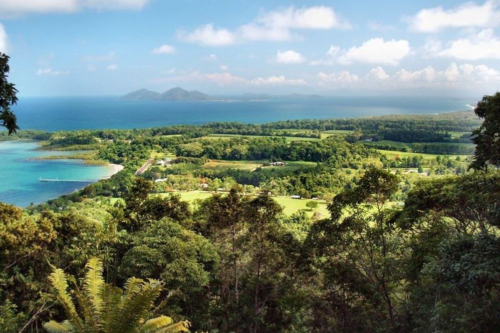
Local Walking Tracks – Bicton Hill Walk
BICTON HILL WALK 4 KM - 1 -2 HOUR WALK Bicton Hill Walk is 4.5 km north of of Mission Beach Village on the Bingil Bay Road. This four kilometer circuit track up Bicton Hill at Bingil Bay is in the... Clump Mountain National Park, and has unsurpassed views and an enormous variety of rare rainforest plants and animal life, one of which is the unusual nesting site of the buff-breasted paradise-kingfisher - They nest in termite mounds here in summer. Between October and March, watch the evening spectacle of migratory pied imperial-pigeons returning to the islands after foraging for food on the mainland. Sturdy plants on the eastern side such as brush box and swamp mahogany are able to withstand the high winds and occasional cyclone. On the western side the vegetation changes. Look for strangler figs, Alexander palms and cycads. One of the famous animals on the hill are the Lace monitors, who have the unusual habit of depositing their eggs in termite nests in trees. The constant temperature inside the nests helps incubate the eggs. Bicton Hill is also home to marsupials such as the nocturnal striped possum. The walk has easy gradients accessible to all areas, with seating at each of the four lookout points. Access to this track is via the carpark - picnic area at Bingil Bay. On completing the walk you may like to swim from one of the deserted beaches across the road (Alexander Drive), or walk along the Drive to the north and at the corner of Bingil Bay Road and Cutten Street are toilet facilities.
Day Tour Suggestions – Waterfalls Galore
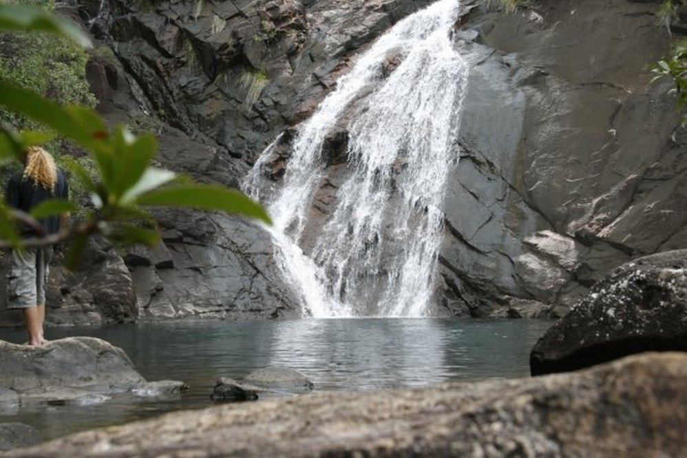
From Mission Beach travel north on the Bruce Highway to Innisfail (58 klm), then take the turn-off (which is on the northern side of the town) for the Palmerston Highway to the Tablelands and Millaa Millaa... - 54 klm. This is an excellent Highway with no narrow bends and very scenic access to the Tablelands. On the way you will see many tropical fruit and organic produce stalls, as well as local tea, so have lots of change for the ‘trust’ till. It is not possible to mention all the picnic places or places of interest or walks, so please check your maps and venture elsewhere, however what is mentioned here, gives you some of the area highlights, hopefully easily found! Mungalli Falls - 44 klm from the Bruce Highway turnoff is a right hand turn for the falls. A scenic, single lane bitumen road in dairy country with majestic Mt. Bartle Frere in the background. One of the highest waterfalls on the Tableland runs over a cliff of thick basalt columns. Above the Falls, the waters form picturesque cascades or rapids. Facilities - toilets, kiosk, and viewing platform. You can continue on and do a scenic circuit, or return to the Highway. From the Mungalli turnoff, continuing up the mountain a further 7.8 klm are the signs for “TOURIST DRIVE 9” and “Theresa Creek Road” This is a 17 kilometer Waterfall Circuit with a stretch of 2.4 klm well maintained dirt road between Ellinjaa Falls and Zillie Falls. Ellinjaa Falls - 3 ½ klm along a bitumen road is the carpark for the falls. The water runs in cascades over a series of lava columns of different heights. The 200 metre natural walking track with some concrete stairs down to the bottom of the falls and creek would be slippery under wet conditions. Picnic tables. A further 2.4 klm (travelling on a well maintained gravel road) is the sign for the Zillie Falls . Park just over the bridge on the left, and walk 60 metres along a track to the viewing area, or as the falls are best seen from below you may like the walk. Shelter at carpark. Bitumen road for a further 7.8 klm takes you to the turn off for the Millaa Millaa Falls - The carpark is just 300 metres away. This is the most scenic of all Tableland waterfalls. Like most other waterfalls, it runs over a cliff of basalt columns. No walking necessary - right at the carpark. Best photos between noon and 2 pm. Facilities - toilets, shelter, BBQ. Returning to the road, turn right towards Millaa Millaa and travel 1 ½ klm to The Falls Teahouse where you can enjoy delicious devonshire teas, lunches and a great view over Millaa Millaa and the local country. Local arts and craft, patchwork, pottery, local tea, coffee and jams for sale. David, Neradeene or Jack will make you very welcome at this delightful teahouse. From the Teahouse, turn right towards Millaa Millaa (1 ½ klm) and make a right hand turn into the main street. The Millaa Millaa Hotel is on the left, the Eacham Historical Museum on the right (open 7 days a week 10.00am till 12 noon) with displays of Aboriginal artifacts, early settler’s history, mining display and historical memorabilia, and the old Cheese Factory on the right. Go to the end of the street, and see the classic statue of the Millaa Millaa Emblem next to the park. Back on the Highway, turn right towards Malanda. Do not take the road directly opposite, as this is your return scenic route if you choose. Turn left at Route 24 to Ravenshoe - 3.3 klm down the highway. Travel towards Ravenshoe for 3 klm and stop at this wonderful lookout. Called either Mc Hugh, Millaa Millaa or Gentle Annie Lookout, it is a left hand turn to the carpark. This is a most popular stop, as it will give you a fascinating lookout on the Tablelands with 180 degree views north towards Atherton and south east to the coast and Innisfail. Continue down the Kennedy Highway towards Ravenshoe, and some 14 klm further on be prepared for a surprise to see some interesting ‘alien’ structures in the countryside. There is a well signed viewing area and carpark on the left. This is a wind farm, with structures standing 46 metres high, and turbine blades 22 metres long ( further information available at the Ravenshoe Visitors Centre). Six kilometers further on brings you to the turn off to the right for Ravenshoe, the highest town in Queensland (920m). This town is the gateway to the Tableland and the Gulf Savannah. This was a timber town, then made way for the dairy industry. It has extra wide streets from the days of bullock teams and horses. The Visitor Centre (immediately on the right) in Moore Street with rainforest displays, Aboriginal culture, timber history and maps of the Army camps during WW II is well worth the stop. Driving down the main street, on the left is the Railco Historic Steam Train. Saturday and Sundays the train departs Ravenshoe at 2.30pm and returns at 4.00pm. Continuing further down the street on the left, is the Highland Bakery, the Historical Museum (inside the real estate office), The Club Hotel - open for Lunch from 12 noon to 2.00pm 7 Days, Wins Gallery with northern landscapes, limited edition prints, local woodcraft, pottery and Bush Poetry (open Wednesday to Sunday 11am to 4pm), The Historical Ambulance Station with arts and crafts Driving up the other side of the main street is the Tully Falls Hotel, various craft shops and Peterson’s Popular Café, with an attached shop with arts, crafts, painting, plants, fruit and free range eggs. The Markets (held in the mornings) are on the 4th Sunday of the month, in the grounds adjoining the Visitors Information Centre. Four kilometers out of town towards Mt. Garnett and 1 klm off the Highway is Big Millstream Falls. These are the widest in Australia during the wet season (45 m). The 300 metre walking track with some steps would have a muddy section in wet weather. There is also a walking track to the bottom of the falls. Best photos in the afternoon. There is shelter, picnic tables and toilets. Returning towards Ravenshoe, depending on your available time, you may like to take a further detour. Just past the BP Service Station is a right hand turn for Tully Falls Road - a scenic forest drive, Tully Falls Lookout (26 klm - The falls are dry most of the year due to the Hydro Station diverting the water), Little Millstream Falls, small but scenic with a picnic spot, Vine Castle - antique exhibits of medieval armor and weaponry, and Koombooloomba Dam (34 klm) where you may like to fish for the famous Barramundi. Heading towards home, you have two options as you leave Ravenshoe. One is to return the same way down the Kennedy Highway to Millaa Millaa, joining the Palmerston Highway or take a slower, scenic route bringing you back to Millaa Millaa. The exit for the alternative route is 2 ½ klm out of town, before the Wind Farm. A right hand turn at the Millaa Millaa sign will take you on a 26 klm scenic route on a narrow, winding bitumen road, with lots of blind corners, and travelling 40 - 60 kph as you enjoy the scenery and this undulating dairy country. After leaving Millaa Millaa for Innisfail, 26 klm down the range on the left side is an area to stop at Crawfords Lookout, giving you a spectacular view of the Johnstone River Gorge. On towards Innisfail and Mission Beach. Obviously there is so much more to see on the Tableland - the dairy country of Malanda, the enchanting Yungaburra and the crater lakes Eacham and Barrine, Atherton and the amazing Crystal Caves, or Lake Tinaroo for some serious barramundi fishing. There are gold panning and gemstone fossicking tours, joy flights and hot air ballooning, houseboats, horseback riding and many guided tours for the various rainforest walks during the day or night. You may enjoy taking another day during your holidays and heading in a different direction - you won’t be disappointed!
Day Tour Suggestions – Babinda Area – The Boulders – Josephine Falls
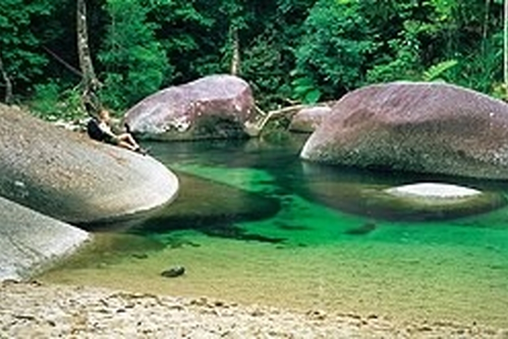
The Boulders - a well known picnic, swimming, bushwalking and camping area. It is 7 kilometers from the Bruce Highway and well sign posted. The Boulders are a series of huge spheroidal outcrops of granite... strewn along Babinda Creek, amongst volumes of sparkling, cascading clear mountain water. The area is shrouded in Aboriginal Legend where a beautiful young Aboriginal girl entices young men into the water, and they disappear. This legend has been reinforced in recent times by many deaths of single males visiting the area, so ensure you swim only in the areas designated as ‘safe’, as dangerous undertows may exist through and under the boulders. The area is surrounded by lush tropical rainforest, with large varieties of birds and animals. Various walks include - Devils Pool walk to Boulders Lookout - 100 m; to Devils Pool Lookout - 470 m; to Boulders Gorge Lookout - 600 m; or Rainforest Circuit Walk - 850m. Returning towards the Highway, you may like to stop at the Art Deco style Pam Schultz Gallery, on Boulders Road - 2 klm from Babinda. It is open Thursday to Monday from 10.00am to 5.00pm and features representational paintings of this famous artist of the wet tropics, Great Barrier Reef, local flora and fauna and the North Queensland sugar cane industry. Handcrafted woodwork, pottery and jewellery is also on display. On the Bruce Highway travelling south from Babinda is Miriwinni. Here you can take a turn off for Bramston Beach and discover this sleepy beachside village, or if you are a keen birdwatcher, stop at the Eubenangee Wetlands before Bramston Beach. This area is home to many birds and wildlife including crocodiles. There is a 1 klm walking track; take the short walk to the top of the hill to appreciate the wetlands and great views. (Don’t forget some insect repellent). If this doesn’t appeal, south of Miriwinni is the turn off for the Josephine Falls, just 8 klm off the Highway. These spectacular cascading falls are a favourite place with the locals to take a rainforest walk, or a swim. Only a ten minute walk to the falls. If you have the time and the energy, and haven’t investigated Innisfail, it has some old and impressive buildings and an interesting multicultural history. The Historical Society is in Edith Street for more information and maps.
Day Tour Suggestions – Licuala Walk/Alligators Nest
Here is a 1.6 km circuit with interpretative signage and suitable for children. You may see the rare and beautiful cassowary, the famous iridescent blue Ulysses butterfly or scrub turkey, parrots or wallabies. Continue... driving towards Tully. At the Highway, turn south toward Tully. From the Highway turn right into Butler Street, the main access into Tully, then right into Murray Street following the cane train tracks. There are two more right hand turns, and the road is called Murray Street all the way. Continue until you see the signs for ‘Alligators Nest State Forest Park’ where you turn left. From Tully to this point has been 5.8 klm. It is only a further 800 metres to the car park, a beautiful rainforest stream for swimming, picnics or BBQ. Crystal clear water and magnificent surroundings. Toilets, water but no kiosk and definitely NO crocodiles or alligators!! Return to Tully, the same way, and left onto the Bruce Highway, heading north to El Arish. An alternative way from the picnic spot to El Arish is via Feluga. At the sign ‘Alligators Nest State Forest Park’ travel straight ahead. Continue over the Bookal Bookal Creek. Watch out at the train crossings during cane crushing season. Take the first right at the sign saying “Feluga”. Travel past the Feluga School and onto the Feluga Hotel on the corner (5 klm from the Alligators Nest Sign). Follow the road towards the Highway. LOOK OUT FOR TRAINS - DANGER, over the lines, and onto the Highway, where you turn left towards El Arish. Turn right at the Mission Beach turnoff. Mission Beach is approx. 15km.